Satellite Imagery Privacy: Can a Satellite Photograph Your Home, and Is It Legal?
Satellite imagery privacy explained: why satellites may legally photograph your home, what US licences ignore and how the Fourth Amendment and GDPR apply.
“Can a satellite see my house?” is one of the most common questions people ask about space. The answer is yes, and has been for years. The more useful question is what the law allows anyone to do with that picture. Here the answer is less comfortable than most people expect: the rules that govern Earth observation satellites were written to protect national security and the interests of governments, and individual privacy sits almost entirely outside them.
What a satellite can actually see
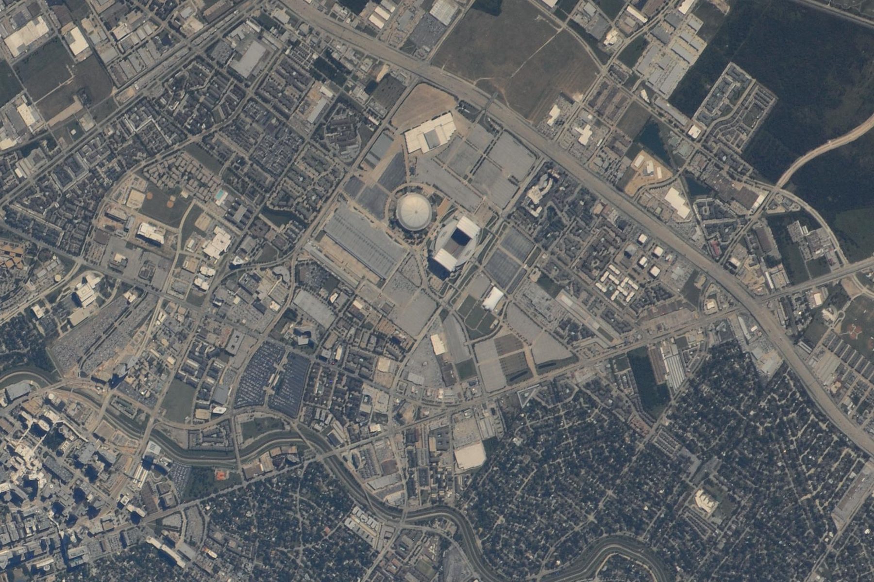
The featured image on this page was taken by hand from the International Space Station with a long lens. NASA describes it as having a resolution of 2 to 3 metres per pixel, “one of the highest spatial resolution images yet obtained from the space station.” You can see the stadiums, the parking lots and the pattern of the streets. You cannot see a person.
Commercial satellites do far better. In December 2021 the US company Albedo announced that it had received a NOAA licence to sell imagery at 10 cm resolution, a first in the United States, and it launched its first satellite, Clarity-1, in March 2025. At 10 cm a car is dozens of pixels, and a garden shed, a trampoline or a new extension is plainly visible. A person standing in the garden is a handful of pixels: detectable, but not recognisable. Faces, number plates and anything inside a building remain out of reach of any lawful commercial system I know of.
That limit is physics and economics, not law. Where the law has set resolution limits, it has done so to protect States, not people. The Kyl-Bingaman Amendment, for example, restricts how detailed US-licensed imagery of Israel may be. In July 2020 Commerce raised the permitted resolution from 2.0 metres to 0.4 metres because finer imagery was already available from foreign sources.
The US licence protects security, not privacy
Anyone operating a private imaging satellite from the United States, or any US person operating one anywhere, needs a licence from the Department of Commerce under 51 USC chapter 601 and 15 CFR Part 960. Our explainer on NOAA remote sensing licences sets out how it works, and our guide to who regulates space in the US shows where it sits beside the FAA and the FCC. The conditions deal with national security, foreign policy, encryption, disposal and the ability to obey “limited-operations directives” during a crisis. None of them protects the people being photographed.
That was a deliberate choice. When Commerce adopted the current rule, some commenters asked it to address privacy. Its answer, in the final rule of 20 May 2020 (85 FR 30790, at 30802), was short: “such concerns are outside the scope of the Act. These requests are better addressed to Congress.” Congress has not taken up the invitation.
Another commenter worried about a standard licence condition that requires operators to give a foreign government data about its own territory on request. Commerce replied that the statute requires the condition, and that it traces back to a 1986 UN General Assembly resolution.
International law looks after States, not residents
That resolution is the Principles Relating to Remote Sensing of the Earth from Outer Space, resolution 41/65 of December 1986. Principle IV ties remote sensing to the freedom of exploration and use in Article I of the Outer Space Treaty, and requires “respect for the principle of full and permanent sovereignty of all States and peoples over their own wealth and natural resources”. Principle XII gives the “sensed State” access to data about its territory “on a non-discriminatory basis and on reasonable cost terms.”
What the Principles do not do is require anyone’s consent. The sensed State gets access, not a veto, and the individual living in the sensed State is not mentioned at all. That is why no country can stop a foreign satellite photographing its territory as a matter of international law, and why no person can either.
When the government is watching: the Fourth Amendment
In the United States, the sharpest limits apply when the government is the one looking. Three Supreme Court cases frame the issue.
On 19 May 1986 the Court decided two aerial surveillance cases. In California v. Ciraolo, police flew over a fenced back garden at 1,000 feet and saw marijuana plants; the Court held that this naked-eye observation from public airspace was not a search. In Dow Chemical Co. v. United States, the Environmental Protection Agency photographed a chemical plant from the air with a mapping camera, and again there was no search. But the Court added a warning that has been quoted ever since: “surveillance of private property by using highly sophisticated surveillance equipment not generally available to the public, such as satellite technology, might be constitutionally proscribed absent a warrant.”
In 2001 Kyllo v. United States turned that idea into a rule. Where the government “uses a device that is not in general public use, to explore details of a private home that would previously have been unknowable without physical intrusion”, it is a search and presumptively needs a warrant.
Here is the problem for privacy. In 1986 satellite imagery really was “not generally available to the public”. Today anyone can buy it. On a literal reading of Kyllo, the commercial market has weakened the protection the Court seemed to promise.
Persistent surveillance may change the answer
The better argument now comes from a different line of cases. In Carpenter v. United States (2018), the Supreme Court held that the government needs a warrant to obtain historical cell-site records, because they reveal the whole of a person’s movements over time.
On 24 June 2021 the full Fourth Circuit applied that reasoning to the sky. In Leaders of a Beautiful Struggle v. Baltimore Police Department, 2 F.4th 330, Baltimore had contracted for planes to photograph most of the city for about twelve hours a day. The images were so coarse that people appeared only as blurred dots. The court still held, by eight votes to seven, that police access to the data was a search, because the stored imagery could be combined with other information to track individuals’ movements over time.
The case concerned aircraft, not satellites, and it binds only one federal circuit. But it shows the logic that will matter as constellations move towards several images of the same place every day. A single satellite photograph of a house is unlikely to be a search. A searchable archive that lets investigators follow a person’s car from home to work over months is a different thing, however low the resolution.
Europe and the UK: data protection does the work
European law approaches the issue from the other end. It does not regulate the satellite; it regulates the processing of personal data. Under Article 4(1) of the GDPR, mirrored in the UK GDPR, personal data is “any information relating to an identified or identifiable natural person”.
Most satellite images on their own do not identify anyone. But once an image of a house is linked to an address, a land registry entry or an owner’s name, it can become information relating to an identifiable person, and the controller then needs a lawful basis and must respect the data subject’s rights. Insurers, planning enforcement teams and tax authorities using imagery to assess particular properties should assume they are inside data protection law. So should a UK satellite operator: a licence from the CAA, described in our UK space law explainer, does not take its imagery business outside the UK GDPR.
National space laws in Europe, where they deal with imagery at all, again look to security. Germany’s Satellite Data Security Act (SatDSiG) requires operators of high-grade Earth observation systems to be licensed and requires a sensitivity check before certain data is distributed. The concern is harm to German security and foreign relations, not the privacy of the people in the frame.
What I would watch
The first is resolution and revisit. Very low Earth orbit systems licensed at 10 cm, combined with constellations that image the same place several times a day, are what make the Baltimore reasoning relevant. Watch which systems NOAA places in Tier 3, the category for capabilities with no existing equivalent.
The second is the courts. The first case in which a defendant challenges the warrantless use of a commercial satellite archive under Carpenter will tell us whether “generally available to the public” or “the whole of a person’s movements” carries more weight.
The third is Congress. Commerce told commenters in 2020 that privacy was a matter for Congress. Any reform of the remote sensing statute is the natural place for privacy language, and so far none has been added.
The fourth is European enforcement. A data protection authority ruling on property-level satellite analytics would set the practical rules for an industry that sells exactly that.
Questions people actually ask
Is it legal for a satellite to photograph my house?
Yes. No space treaty and no general rule in US, UK or EU law requires consent before a satellite images private property. In the US, commercial imaging satellites need a Department of Commerce licence, but its conditions protect national security, not the privacy of the people photographed.
Can satellites see people or faces?
Satellites can detect people but not recognise them. In 2021 the US licensed Albedo to sell imagery at 10 cm resolution, the first such licence. At that resolution a person is only a few pixels, so faces and number plates cannot be read.
Does NOAA regulate satellite imagery privacy?
No. In its May 2020 remote sensing rule, the Department of Commerce said privacy concerns were “outside the scope of the Act” and “better addressed to Congress”. NOAA licences address national security, foreign policy and international obligations.
Can the police use satellite images without a warrant?
Often yes for a single image, under the 1986 Supreme Court aerial surveillance cases. But Kyllo (2001) and Carpenter (2018) limit technology that reveals details of the home or the whole of a person’s movements, and in 2021 the Fourth Circuit held that access to Baltimore’s persistent aerial surveillance data was a search requiring a warrant.
Is satellite imagery personal data under the GDPR?
It can be. An image becomes personal data when it relates to an identified or identifiable person, for example when an image of a house is linked to its owner’s name or address. Raw imagery that cannot be linked to anyone usually falls outside the GDPR.
Can a country stop foreign satellites from imaging its territory?
No. Under the 1986 UN Principles on Remote Sensing, the sensed State has a right of access to data about its territory on reasonable terms, but no right to prevent the imaging. States can only control operators under their own jurisdiction.

Rahul BaggaFounder and Advisor, Space Law Journal
Rahul Bagga is a Partner at Dentons Link Legal and a Founder and Advisor of Space Law Journal.
Space Law Journal is a joint initiative of Legal Desire Media and Odyogeek. Spotted something we got wrong, or want to respond? Write to space@legaldesire.com.